Project Overview
Project Name: Using Geospatial Algorithms to Modernize Land Records
Partners: Directorate of Land Records (DoLR), Govt. of Maharashtra and Google Research
Sector: Land Records
Categories: GIS Data Structures and Algorithms
Current Team:
- Professor Milind Sohoni
- Professor Bharat Adsul
- Aaryan Dangi
- Lisan Kadivar
- Shashwat Prakash
Description: The Government of Maharashtra is looking to modernize land records, and create geo-referenced (latitude-longitude) ownership plots that are as close a match to ground reality as possible. There are several resources we have at our disposal: village paper maps that often date back to the 1800s, satellite images segmented into polygons that represent distinct farm plots (provided by Google), and some other textual/geometric data for each survey plot.
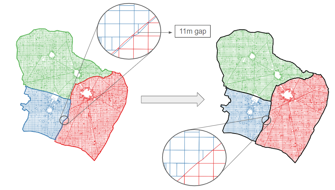
The central problem we face is that the old paper-based maps don’t match the actual farm boundaries that currently exist; rivers have changed paths, ownership of land has been subdivided, and, most importantly, the old techniques of mapping weren’t precise at all, especially by today’s standards. Hence, there is no one legal map for any village: this is not good news, given the number of legal disputes currently awaiting resolution.
Hence, our task is to take the space partitions of polygons, that is the survey map, first digitized and scaled appropriately, and transform it mathematically (using operations such as rotations, translations, node shifts, etc) to match farm plot boundaries while ensuring minimum deviation in parameters such as area/shape index. We are also looking to explore similar areas, such as creating crop water deficit models for insurance and food agencies.
Current Status
We've been working with the Settlement Commissioner and Department of Land Records (SC & DLR) for many months, and are in the process of delivering over a year-long MoU, as it pertains to the digitisation and transformation of land records. We are currently in Phase B of the project, where we aim to try our algorithm end-to-end and refine it on several pilot villages. See this for a quick introduction.
As a team, we are quite technically mature, having worked with Google’s farm plot segmentation and village maps for over a year now. Our algorithm has developed to become fairly sophisticated, going from global scaling and rotation to region-wise rotation/translation fits, node-by-node BFS, and as of most recently local spline transformations and priority-based face fit. Much of the progress we seek to make is using topological attributes of nodes and optimizing farm graph structures to improve output quality.
Skills Learned
Python
PostgreSQL
PostGIS
QGIS
Data Structures & Algorithms
Topological Operations
Field Work
Documentation and Delivery
Qualifications Required
Year: Second year and above
Experience: Some familiarity with Python is required. Familiarity with Data Structures & Algorithms is appreciated, and so is an interest in maps and geometry.
Work Description
Roles: 2 GIS Algorithm Development
Stipend: Paid project (join community for more details)
Project Duration: 3-4 months
Tasks/Deliverables:
- Understand and improve upon the algorithm developed for minimizing mismatch between farm boundaries and ownership plots
- Develop validation metrics and relevant plugins for parameterising shift and mismatch of ownership polygons pre and post-processing
- Create web GIS interfaces and carry out analysis for demonstration purposes
- Understand and communicate requirements of relevant parties
- Undergo field visits for better understanding of the problem
How to Apply?
Submission link: https://forms.gle/fhUncTmUu8TqAewo6
Deadline: 11:59 PM, 18th October, 2024
To enroll for the project, you must fill the form above. You must attempt and submit the assignment below to the best of your abilities, taking aid of any tools online. We will contact you personally if you are shortlisted for the interview.
Assignment: Getting familiar with GIS
This problem will involve getting familiar with the tools we usually use and performing some basic queries and operations using them.
The sawangi.shp file contains the ownership plots of the sawangi village in the Amaravati district. (Shape file can be located here- https://drive.google.com/file/d/1OeR0WB-6TAQQzAI5tcQIt0JVxc59asWH/view?usp=share_link)
- Load the sawangi.shp shapefile into QGIS and add the screenshot in your report.
- Insert the shp file into your Postgres database (dbname=sawangi_test) and report the datatype of each column.
- Write the answer to each of the following questions along with the SQL query in your report.
- Number of polygons with an area greater than 5 Ha.
- Delete polygons with the value of the pin column as NULL and report the number of columns deleted.
- Total perimeter of the sawangi village.
Note: The SRID for sawangi.shp is 32643. Feel free to use this information anywhere as required.
Assignment guidelines: You must submit a single pdf file titled {your_name}.pdf on the Google Form. The pdf report should include the images, queries and results for the assignment.
Contact Us
For any general queries, join the ProSpace WhatsApp group- here.
For assignment queries, contact:
Email: aaryan.dangi@iitb.ac.in
Phone: 9987361968
Announcements
Recruitment Open: Geospatial Algorithms
01-Feb-2024Recruitment for the Modernising Land Records project is now open! Join the project and gain valuable skills in Python, PostgreSQL, PostGIS, QGIS, DSA and more. Check out the submission link and assignment to apply.